Wednesday, October 31, 2012

Sandy Fallout

The skyline, as seen from the Promenade last night. Aside from a few buildings in Battery Park City, Lower Manhattan is dark, as are Jersey City and Governors Island. Note the termination of the Brooklyn Bridge lights as they approach Manhattan. It's pretty eerie.


Monday, October 29, 2012

Sandy Update 1

An hour or so ago on Henry Street:


In case you're wondering, those are two metal pipes that were securing the bottom of that banner to the St. George Tower.

The Calm Before...

Sandy has yet to hit NY, but the tide is already as high as during the worst part of Irene last year. Van Brunt Street in Brooklyn is flooded at the south end, and Valentino Pier is supposedly underwater. Meanwhile, Brooklyn Bridge Park is submerged farther than I've ever seen it. Maura and I took Blue for what might be her last walk for awhile, surveying the scene from the Promenade.

The wetlands at Pier 1 are nearly completely submerged.

The timber piles at Pier 2 are no longer visible.

Also at Pier 2, the Tidal Pool has nearly reached capacity.

Newly-installed and newly-threatened: the synthetic playing fields at Pier 5. 
Many Brooklynites took to the Promenade this morning.
Maura and Blue

Saturday, October 27, 2012

Open House New York, Part I: Brooklyn Bridge Park Pier 5

A few weeks ago, Maura and I took advantage of a couple of Open House New York events, both in Brooklyn. For those who don't know, OHNY sponsors a weekend every October in which sites throughout the city--parks, museums, shops, studios, other buildings of architectural and historical interest--open up their doors to the public.  Regular followers of the blog (all six of you) are no doubt aware of my acute interest in the progress of construction at Brooklyn Bridge Park (see here, here and here). So it should come as no surprise that Maura and I jumped at the chance to take a tour of the construction site at Pier 5, due to open in November.


Satellite view of Pier 5 (Google Maps underlay)


For months and months, there appeared to be no progress at Pier 5. But as our (extremely knowledgeable) tour guide pointed out, much of the work has been happening underwater. Most of the park is developing on man-made structure, built on around 12,000 timber piles. Many of those piles have required major repairs, involving the encasement of the timber in concrete. If you're feeling nerdy, take a look at the technical specifications for this procedure at Pier 6. Otherwise, the concrete-wrapped piles are visible in the photo below.


Pier 5 from the southeast. Lower Manhattan is in the background.


Now, the public face of the pier is really starting to take shape. While we were there, workers were installing the subsurface of soccer fields (there will be three on the pier), mocking up potential locations for barbecue grills (there will be 25, available to the public on a first-come, first-serve basis) and sweeping a newly-poured concrete bridge. 


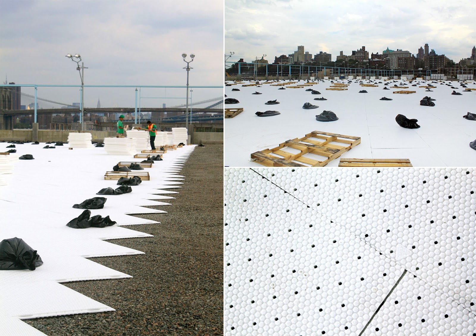
Polystyrene substrate for shock absorption beneath athletic fields, perforated to allow drainage to gravel

Installed playground equipment and mocked-up site furnishings on the "picnic peninsula" 
Bridge connecting picnic peninsula to mainland


In the photo above, you can see that the "Picnic Peninsula"--or as I think I'll start calling it, the Barbecue Boardwalk--is separated from the mainland. In fact, the pier was cut away from the mainland. It now forms a buffer for a marsh much like that at Pier 1. As I said earlier, while it still looks like this section of the park is far from completion, there are signs that it will rapidly spring to life. In no time, the wetland grass will be overgrown (if Pier 1 is any indication), and the seeded areas (like in the photo below right) will turn to grass.


L-R: Wetland habitat; future grassy area


Elsewhere on the pier, a week's time is enough to witness a complete metamorphosis. In the upper righthand photo below, you can see galvanized steel girders resting quietly on grade. Only days after our tour, a prefabricated concrete concession stand had been installed on top of them.


Clockwise from left: expansion joint connecting two sections of the peninsula, galvanized steel girders awaiting a pre-fabricated concrete concession stand (since installed), and a base detail of one of the lights for the athletic field.


And a week after our visit, the workers had begun to hang the fabric sunshades that will line the perimeter of the playing fields, above built-in concrete seating. Renderings on the park's website illustrate what the completed field should look like. As much as possible, the design team sought to refurbish and repurpose elements of the piers and buildings that had inhabited the site. In this case, the light blue superstructure and concrete footings and foundations were retained from the warehouse that previously stood here. Similar buildings still stand just south of Pier 6, across Atlantic Avenue. Throughout the site, timber beams were reclaimed from the warehouses, and now serve as park benches.


Refurbished steel structure and fabric sunshade

Beyond the building structure, the concrete deck surrounding it was also retained. Approximately 20' wide for most of its length, it will allow circulation around the soccer fields and access to the waterfront. At the western end, jutting out into the east river, it offers a spectacular panoramic view of the Brooklyn Bridge, Lower Manhattan, Ellis Island, the Statue of Liberty and Governors Island.


L-R: west end of Pier 5; gated section of fence on south side of Pier 5 (to allow access to and from boats), with Governors Island in the background


Circling to the north side of the pier, we caught a glimpse at what may come. The most unassuming of the six piers sits in repose just up the river. Pier 4 consists of a former railroad float transfer bridge that served the warehouses and Brooklyn. Today it is sinking into the river. Eventually, it will become a protected habitat.


View of Pier 4 and Lower Manhattan


Expect another update on Pier 5 in the near future. In addition to the interim progress I've noted above, the barbecues have been set, tether ball courts have been rigged, and the synthetic turf has been rolled out. Stay tuned!

Wednesday, October 24, 2012

A Little Light Reading...

With the election season coming down to the wire, the World Series upon us and Taken 2 finally in theaters, it would take something completely momentous and utterly enthralling to draw your attention elsewhere. The Mayan prophecy? Nope. The discovery of intelligent extraterrestrial life? Huh-uh. How about a primer on the costs and benefits of polystyrene as a building material? Yep.

For more, see my latest post on the FXFOWLE blog, "Goodnight, Styrene?"  It's part of a month-long look at the life cycles of building materials. Hold on to your seats.

Monday, October 1, 2012

Ones and Twos: Presidential Pardon

Once upon a time, the residents of Brooklyn Heights deemed our 5th President worthy of a street. Then along came an Anglophile who decided some now-obscure 16th-century British nobleman should have the street instead. He instigated a whole Doctrine that for better or worse would influence two centuries of foreign policy, but maybe a street name was a little too much. Nonetheless, Monroe Place eventually found a new home farther north.

Starting just around the corner from the Brooklyn Historical Society on Pierrepont, Monroe Place runs north to Clark, terminating at the base of the Cadman Tower housing complex. According to Gerard Wolfe in New York: A Guide to the Metropolis, Monroe Place is the widest street in Brooklyn Heights. This affords the homes ample front gardens, as you can see in some of the photos below. In a disorienting twist, it's also the only street in the neighborhood in which the even-numbered houses stand on the east side of the street.

Monroe Place from the north (L) and south (R)
At the south end of the street, across Pierrepont from the Historical Society, stands the First Unitarian Church, also known as the Church of the Saviour. Designed by Minard Lafever and built in 1844, the Gothic Revival church is the oldest existing church in Brooklyn Heights. The BHS blog has an informative post on the church's creation, along with several images of Lafever's original drawings. Several decades after its construction, the church was retrofitted with stained glass windows designed by Louis C. Tiffany and his studio. 

Church of the Savior, 48 Monroe Place: images of south facade (facing Pierrepont)


L: Detail view of tracery in Rose Window, R: Tiffany window on west facade

Across the street to the west is the Brooklyn Appellate Courthouse, the country's largest appellate court in terms of volume, covering ten counties. The three-story Neo-Classical limestone courthouse was designed by Slee and Bryson and built in 1936. Francis Morrone, author of An Architectural Guidebook to Brooklyn, gives us this gem of a take on the building, which he describes as "Depression Doric":
The building is larger than anything arounds it, it employs its forms rather grandly, it  is white in a sea of reds and browns, and it is elevated from grade level. It sounds like a pure prescription for disaster, yet it is anything but. Somehow the building not only works in its context but enhances it. The scale of the building is impressive, not jarring, and its hard to imagine this part of Brooklyn Heights without it. (85)
Here's a look...

Brooklyn Appellate Courthouse, 45 Monroe Place

A dilapidated 3-story brick building at the north end of the block provides an unexpectedly rich palette, with an overrun cast-iron urn in its overgrown forecourt, set off against a boarded-up hold-out. Austere yet resplendent, its vermilion facade proudly flaunts its rusty lintels and a shiny black base.


More shots of the block follow below, including a view of the front gardens and details of a few of the row houses. The photo in the bottom right shows a portion of the Cadman Tower complex--part of the Mitchell-Lama housing program and the subject of another post. For now, note the bridge from the 3-story townhouses, which connect to the base of the tower across Clark Street (and previously documented at the end of this post).